Predicting the Potential of Rainfall Disaster Risk using Cellular Automata in Small Urban Declining Areas
ⓒ 2022. KIEAE all rights reserved.
Abstract
In declining cities, it is vulnerable to disaster risks due to the complex reasons such as aging of the buildings, decreases in population and slowly development of infrastructure. When making regeneration plans for declining areas, it is necessary to analyze and predict disaster risks. Therefore, this paper aims to predict the potentials of disaster risks in small-scale declining areas in cities that show risks in the future.
This study predicts potential of disaster risk by using cellular automata. By simulating the heavy rainfall disaster using RCP scenarios, 10-year unit change simulation results for heavy rainfall disaster risk are acquired. After simulating disasters that affect to the heavy rainfall disaster, we applied cellular automata to obtain a 10-year unit disaster risk potential.
By considering the yearly change values of disaster risk elements in small-scale urban regeneration regions, this study suggests a prediction method of disaster risk potential simulation for heavy rainfall. Our research contributes to the analysis and forecasting of disaster risks in aging small declining areas settings. We expect that the suggested model would be helpful to identify disaster risks and prioritize urgent areas in small decline cities in the future.
Keywords:
Declining Cities, Urban Regeneration, Disaster Risk Prediction키워드:
쇠퇴지역, 도시재생, 재난위험성 예측1. Introduction
In declining cities, social, economic, and environmental status are changing [1]. When cities are declining, many residents have limited resources and public infrastructure becomes vulnerable [2]. When developing regeneration plans, it is important to analyze current conditions and predict changes in the future. In particular, various studies about analysis and prediction of disaster risks in declining urban areas have steadily increased. We also previously developed disaster risk assessment framework and analyzed disaster risks in small urban areas [3] although other studies usually analyze and predict disaster risk on macro-scale. However, since those previous studies focus on analyzing current status, it is also necessary to predict disaster risks in the future to establish appropriate plans. Therefore, this study aims to predict a change in disaster risk changes by simulating multiple scenarios and use grid-based cellular automata to predict the potential of disaster risks. Based on RCP (representative concentration pathway) scenarios which are climate changes by setting the greenhouse gas emission values and changes in urban planning factors, we seek to simulate disaster risk changes of heavy rainfall in scoring the yearly changed values for 10-year period. When simulating the results of disaster risks, we seek to apply grid based cellular automata to predict potential of heavy rainfall disaster risk. As a result, this study seeks to demonstrate the predicted potential ratings into a grid that represents the target area with heavy rainfall risk. The rainfall disaster risk potential ranks are visualized with images to identify the range of the predictive risk potential.
2. Literature Review
In urban declining areas, it is vulnerable to various disasters due to a decrease in population and aging of the facilities [4]. It is an important step to analyze and predict disaster risks. Existing studies about disaster risk analysis mainly focused on administrative district units in a relatively large area. Kim and Kim [5] evaluated the vulnerability of disaster at the city level based on the concept of climate change vulnerability. Lim et al. [6] quantified and evaluated the comprehensive disaster diagnosis index for declining areas by city level. Similarly, the comparison and analysis of disaster risks showed that various comparative analysis mainly focused on the national level or city, county, and district levels [7][8].
Existing studies about predicting disaster risks mainly used several scenarios. Ye et al. [9] established the loss model of disaster risk by simulating a representative natural disaster risk scenario in the landscape area and predicted the average annual loss. Yin et al. [10] simulated the flooded area and the depth of the city with a scenario modeling based on a GIS (geographic information system) approach.
Additionally, existing studies mainly used scenarios for various regions and conducted a wide range of predictions suitable for regional situations. They sometimes used climate change scenario such as RCP scenarios to make predictions of disaster risks. Lee et al. [11] evaluated the hydrological risk of flood disasters according to 13 climate change scenarios using the designed flood prediction model. Ahn et al. [12] applied the RCP scenario to predict future heavy snowfall and evaluate vulnerable areas.
Two major limitations exist in those existing studies; 1) their risk prediction mainly focused on macro-scale area and rarely analyzed small areas; 2) since they mainly focused on a large area, it was difficult to identify significant factors in a small area to predict changes in future.
Therefore, we seek to apply climate change scenarios to disaster prediction in small areas and predict the potential of small grid-based disaster risks. To predict the potential of small grid-based regions, we use cellular automata. Cellular automata was mainly used in studies about urban sprawl or urban growth simulation. After classifying the measurement and type of urban sprawl by period using the cellular automata model, relevant studies analyzed spatiotemporal changes in urban areas [13], and urban growth simulations were also popular by combining machine learning and cellular automata models [14]. By combining spatial analysis and data preparation of change in the future, this study seeks to suggest a method to predict potential of disaster risks in a small declining urban area.
3. Methods
3.1. Research Sites and Data Collecting
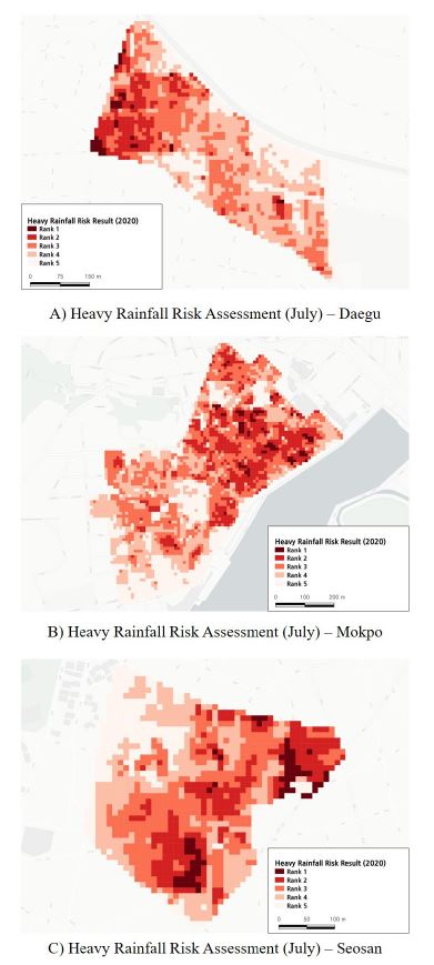
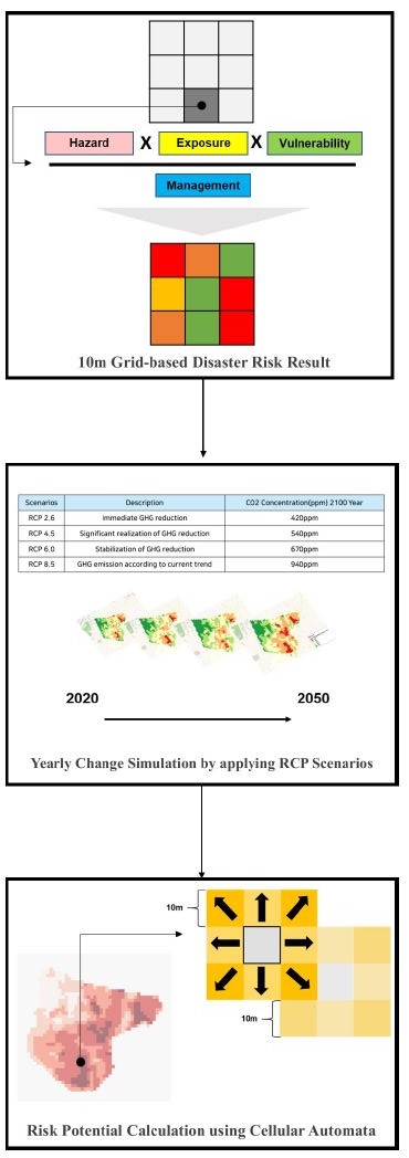
In our previous work [3], we selected three sites for risk assessment. Fig. 1. shows the three sites. The three sites are Daegu, Mokpo, and Seosan. Based on the physical, social and economic degradation of three areas, urban regeneration projects are in processing for those areas [3]. We used four risk indicators of heavy rainfall for each factor. An experiment was conducted in three regions to predict the heavy rainfall risk potential by using the risk analysis results, and the results of predicting the potentials of heavy rain risk in each region were obtained. Fig. 2. shows the research process.
3.2. Risk Simulation by using RCP Scenarios
To predict future risk potential, this study follows three steps: data collection of current values, data generation of future values, and calculation of future risk potential. To begin with, relevant indicators were selected because those indicators with a value vary over time from 12 risk indicators. In Table 2., hazard and exposure indicators were generated every 10 year to predict changes in disaster risk. To generate relevant indicators every 10 year, the RCP scenarios and changeable factors were used. We utilized the RCP scenario to simulate how disaster risk shifts in small declining areas. The changes in indicators according to the RCP scenario was obtained from the government data that used the most recent greenhouse gas concentration figures from the 5th evaluation report to calculate the climate scenario [15].
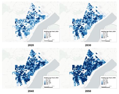
The RCP scenario, which was derived from the IPCC's RCP scenario and adjusted for the Korean context, was used in this study. The representative climate change scenario, the RCP scenario, includes four scenarios. Table 1. shows the descriptions of each scenario. Among them, we chose two RCP scenarios of RCP 4.5 and 8.5 to simulate and predict disaster risks. We simulated hazard factors of heavy rainfall disaster risks by estimating precipitation data according to the RCP scenario by year. We estimated changeable value by year calculated by setting the criteria for the population of vulnerable class trend change and building age (Fig. 3.). The two indicators of exposure factors are indicators that affect built environments and have a 10-year change value.
3.3. Risk Potential Prediction using Cellular Automata
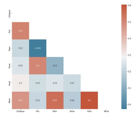
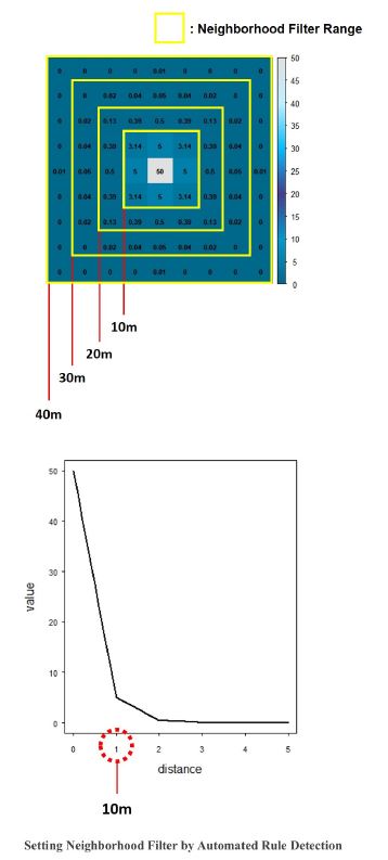
We calculated the disaster risk potential by adopting the land conversion potential in the cellular automata. Like land conversion potential, disaster risk values that can affect potential were required to obtain disaster risk potential. By applying the 10m grid-based risk assessment, we obtained other five disaster risk results. Five disasters were collapse, fire, snow, heatwave, and wind. When obtaining the results, we conducted a correlation analysis. Heatwave and wind were positively correlated with heavy rainfall disasters (Fig. 4.). When setting neighborhood filters to obtain the risk potential, we performed automated rule detection [17] to set the appropriate neighborhood size and filter values. As a result of the automated rule detection, we obtained the range of 10 m filter and the values, which are an appropriate size of the neighborhood (Fig. 5.).
4. Results
With simulated results of disaster risks and influential neighborhood filters using cellular automata, and calculated the risk potential (RP) of heavy rainfall risk. We got the change values of simulated results for each influenced disaster risk on heavy rainfall risk and the values were multiplied with neighborhood value (N). (Eq. (1)). Therefore, we calculated the risk potential for heavy rainfall every 10 year, 2030, 2040 and 2050.
| (Eq. 1) |
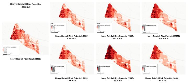
By comparing the results of the heavy rainfall disaster risk analysis in 2020 with the risk potential of 10 years unit until 2050 according to the RCP 4.5 and 8.5, it is found that risk would become more severe. Fig. 6. illustrates the potential for heavy rain risk in Daegu in 10-year units, respectively, according to the RCP scenarios. According to the result by the RCP 4.5 scenario, the risk area is slightly wider than the existing risk area and the range is gradually expanded. According to the result by the RCP 8.5 scenario, the risk area is expanded, and the risk potential of disaster becomes more severe in 2050 due to the influence of precipitation in the 8.5 scenario.
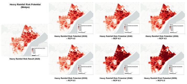
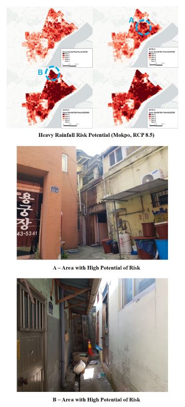
According to the results in Mokpo in Fig. 7., the potential for heavy rain risk gradually increases year by year. In both 4.5 and 8.5 scenarios, the risk potential increases to a wide range around existing risk areas, and by 2050, the degree of risk also increases significantly.
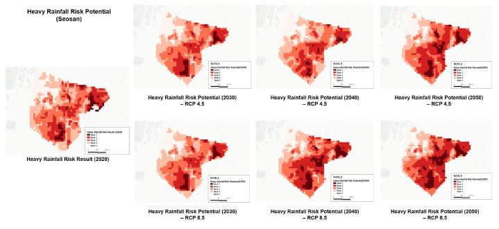
According to the results in the Seosan area in Fig. 8., both the RCP 4.5 and 8.5 scenarios gradually expand their risk potential range, and the degree of risk increases over time every 10 years. In particular, a field survey photo of Area A and Area B in Mokpo of Fig. 9. demonstrate that the risk range can increase and the degree can increase in the area with a high risk of existing disasters as the building ages and the influence of other disaster risk increases.
Thus, these findings demonstrate the potential of disaster risk for specific areas in small declining cities. In particular, theses results demonstrate that it is necessary to establish appropriate plans such as the expansion of reduction facilities and equipment for high disaster risk areas preparing for climate change.
5. Discussion
In this study, we predicted the potential for heavy rainfall disaster risk. According to the results, it is found that the risk potential gradually widens and expands on those small declining areas in the cases. Potential ranks help visualized potential risks to develop appropriate planning approaches in small-scale declining areas for preparing disasters. Eventually, we developed a novel method for predicting the long-term risk of disasters specific to small areas and demonstrate the changes in disaster risk by spatial unit and disaster type. In addition, according to the results, it is possible to prepare a strategy for reducing disasters from a mid-term to long-term perspective and establish an appropriate urban management system for urban regeneration areas. In particular, this study sought to develop a method to predict disaster potential in small declining areas in the future. The developed model in this study is expected to be useful to establish more specific plans by using the analysis and prediction results of small areas, and helpful to make plans in consideration of various scenarios and impacts by predicting the potential influence of disasters.
6. Conclusion
This study predicted the risk potential for heavy rainfall disasters in small declining areas. Based on the risk assessment results, we developed a potential prediction model by using cellular automata to find the disasters that are mutually influential. After conducting a disaster risk analysis, the potential were calculated by cellular automata based on the correlation between other disaster risks. As a result, we demonstrated the potential prediction results in the small declining area, which helps establish countermeasures to prepare for disaster risk. Further studies are expected to conduct by using the results. In addition to the heavy rain potential prediction results, it is possible to predict the risk potential for various disasters and to provide technical support and disaster prevention products for small areas.
Acknowledgments
This research was supported by a grant (22TSRD-C151228-04) from Urban Declining Area Regenerative Capacity-Enhancing Technology Research Program funded by Ministry of Land, Infrastructure and Transport of Korean government.
References
-
J. Yu, J. Li, W. Zhang, Identification and classification of resource-based cities in China, Journal of Geographical Sciences, 29(8), 2019, pp.1300-1314.
[https://doi.org/10.1007/s11442-019-1660-8]

-
G. Kim, G. Newman, B. Jiang, Urban regeneration: Community engagement process for vacant land in declining cities, Cities, 102, 2020, 102730.
[https://doi.org/10.1016/j.cities.2020.102730]

-
GY. Byun et al., Analysis of the Disaster Risk Assessment for Urban Declining Areas by Applying Weights of Risk Indicators: Focused on Heavy Rainfall and Snow, KIEAE Journal, 21(6), 2021, pp.23-30.
[https://doi.org/10.12813/kieae.2021.21.6.023]

-
C. A., Bindu, S. Vishnudas, Measuring Disaster Resilience at Community Level and Exploring the Prospects of Revitalizing Communities Coalescing Disaster Risk, A System Engineering Approach to Disaster Resilience, 205, 2022, pp.291-302.
[https://doi.org/10.1007/978-981-16-7397-9_21]

-
김선명, 기후변화 취약성 평가에 관한 연구, 한국거버넌스학회보, 제19권 제2호, 2012, pp.99-123.
S.M. Kim, A study on vulnerability assessment to climate change -Focused on 22 municipalities of JeollaNamDo-, The Korean Governance Review, 19(2), 2012, pp.99-123. [ https://doi.org/10.17089/kgr.2012.19.2.005 ]
-
임효진 외 4인, 쇠퇴지역 재난· 재해 종합진단지수 개발과 지역간 위험성 비교· 분석-서울시 사례, 지역연구, 제37권 제4호, 2021, pp. 33-47.
H.J. Lim et al., Development of a comprehensive diagnosis index for disasters in declining areas and comparison of risks between regions: A case of Seoul, Journal of the Korean Regional Science Association, 37(4), 2021, pp. 33-47. -
한승룡, 강나래, 이창수, 복합위험요소에 대한 도시지역의 재해위험도 평가, 한국방재학회지, 제15권 제3호, 2015, pp.33-43.
S.R. Han, N.R. Kang, C.S. Lee, Disaster risk evaluation for urban areas under composite hazard factors, Journal of The Korean Society of Hazard Mitigation, 15(3), 2015, pp.33-43. [ https://doi.org/10.9798/KOSHAM.2015.15.3.33 ]
-
김승우 외 3인, 재난자원 관리계획 수립을 위한 재난 위험성 평가, 한국방재학회지, 제18권 제2호, 2018, pp.387-394.
S. W. Kim et al., Disaster risk assessment for the disaster resources management planning, Journal of The Korean Society of Hazard Mitigation, 18(2), 2018, pp.387-394. [ https://doi.org/10.9798/KOSHAM.2018.18.2.387 ]
-
X. Ye et al., Natural disaster risk assessment in tourist areas based on multi scenario analysis, Earth Science Informatics, 15, 2020, pp.1-12.
[https://doi.org/10.1007/s12145-020-00518-w]

-
Z. Yin et al., Community-based scenario modelling and disaster risk assessment of urban rainstorm waterlogging, Journal of Geographical Sciences, 21(2), 2011, pp.274-284.
[https://doi.org/10.1007/s11442-011-0844-7]

-
J.Y. Lee et al., Evaluating the hydrologic risk of n-year floods according to RCP scenarios, Water, 13(13), 2021, pp.1805-1818.
[https://doi.org/10.3390/w13131805]

-
안소라, 이준우, 김성준, RCP 기후변화 시나리오에 따른 미래 강설량 예측 및 폭설 취약지역 평가. 대한토목학회논문집, 제35권 제3호, 2015, pp.545-556.
S.R. Ahn, J.W. Lee, S.J. Kim, Projection of future snowfall and assessment of heavy snowfall vulnerable area using rcp climate change scenarios, Journal of the Korean Society of Civil Engineers, 35(3), 2015, pp.545-556. [ https://doi.org/10.12652/Ksce.2015.35.3.0545 ]
-
정고은, 김영호, CA (Cellular Automata) 와 ARD (Automatic Rule Detection) 를 이용한 제주도 도시 스프롤의 시공간적 변화 예측 모델링, 한국지리학회지, 제10권 제1호, 2021, pp.139-152.
G. Jung, Y. Kim, Modeling of spatio-temporal changes of urban sprawl in Jeju-island: Using CA (Cellular Automata) and ARD (Automatic Rule Detection), Journal of the Association of Korean Geographers (JAKG), 10(1), 2021, pp.139-152. [ https://doi.org/10.25202/JAKG.10.1.9 ]
-
Y. Feng, Y. Liu, M. Batty, Modeling urban growth with GIS based cellular automata and least squares SVM rules: a case study in Qingpu–Songjiang area of Shanghai, China. Stochastic environmental research and risk assessment, 30(5), 2016, pp.1387-1400.
[https://doi.org/10.1007/s00477-015-1128-z]

-
C.B. Field, V.R. Barros, Summary for policymakers In: Climate Change 2014: Impacts, Adaptation, and Vulnerability. PartA: Global and Sectoral Aspects. Contribution of Working Group II to the Fifth Assessment Report of the Intergovernmental Panel on Climate Change, IPCC, 2014, pp.1–32.
[https://doi.org/10.1017/CBO9781107415379.003]

-
기후정보포털, http://climate.go.kr/home/CCS/contents_2021/Definition.html#, ; 2022.01.13.
Korea Meteorological Information Portal, http://climate.go.kr/home/CCS/contents_2021/Definition.html#, ; 2022.01.13. -
M.S. Roodposhti, R.J. Hewitt, B.A. Bryan, Towards automatic calibration of neighbourhood influence in cellular automata land-use models. Computers, Environment and Urban Systems, 79, 2020, pp.101416-101428.
[https://doi.org/10.1016/j.compenvurbsys.2019.101416]

