A Study on the Berlin Waterfront Development for Urban Regeneration : Focused on the case of Wasserstadt Berlin-Oberhavel, Berlin, Germany
ⓒCopyright Korea Institute of Ecological Architecture and Environment
Abstract
The purpose of this study is to explore the relationship between suburban waterfront und urban regeneration strategies. Specifically, This paper investigates how urban design strategies for suburban waterfront has been conceptualized and realized in a case-based research study of the regeneration of suburban waterfront in Berlin, Germany. Since Germany's reunification, Berlin was faced a wide variety of challenges and has been transformed into a new capital city. First of all, Wasserstadt Berlin-Oberhavel was a key development task for the urban regeneration in Berlin. The Wasserstadt Berlin-Oberhavel project with over 207 hectares will provide new residential urban areas, office spaces, educational facilities and cultural facilities. In details, 3,640 apartments with 12,700 units and around 4,800 jobs will be created.
The study consists of five sections. The first and second section are divided into two stages:“waterfront definition in urban design” and “urban design strategy in waterfront”. The third section explores the waterfront development process of Wasserstadt Berlin-Oberhavel. The fourth section aims to investigate the strategies for urban regeneration as well as waterfront development. Finally, the fifth provides some of the key policy challenges for Urban Regeneration in suburban waterfront area.
The results showed that urban regeneration strategies in suburban waterfront have a substantial impact on all two dimensions: relationship between waterfront and urban context, relationship between waterfront and natural environment.
Keywords:
Urban Regeneration, Waterfront, Wasserstadt Berlin-Oberhavel키워드:
도시재생, 수변공간, 물의도시 베를린 오버하벨1. Introduction
1.1. Research Background and Purpose
The purpose of this study is to derived the strategies and characteristics of urban regeneration applied to suburban waterfront through case analysis of urban regeneration project conducted in the waterfront of the Wasserstadt Oberhavel-Berlin, suburban area of western Germany after Unification Germany. In this way, the urban regeneration project in Korea will be expanded from the urban area to the suburban area, and the implications for the the usefulness of waterfront and development of potential for urban regeneration will be presented.
European cities have faced the limitations of urban growth as the global age accelerates externally and the post-industrialization era comes since the 1980s and the demand of the citizens for the improvement of the quality of life of the urban space suitable for the increased economic standard of living has been bursting like dam water internally the city. Accordingly, the existing urban space is newly defined and a new urban development strategy is sought to improve the quality of settlement environment.
Above all, despite the structural changes of urban space derived from urban regeneration, strategies to maintain and inherit the historical context and identity of the declining urban space were implemented. In this way, the city's tradition and uniqueness are maintained and urban development is achieved, and physical diversification of urban space and quality improvement of settlement environment are planned. In addition, the functions and forms of various urban spaces were formed to accommodate complex urban functions.
Under this European urban regeneration strategy, in this study, we will examine the analysis of Wasserstadt Oberhavel-Berlin, which is the subject of this study. how can the waterfront of suburban area maintain and inherit the tradition and uniqueness of existing city? Also, how can the waterfront, accommodate the multifunctionality of urban spaces and provide a urban space for the leisure and relaxation of urban residents as a universal place?
By deriving thee waterfront urban regeneration strategy of suburban area through analysis of the case of Wasserstadt Oberhavel-Berlin, we will suggest the implications for establishing urban regeneration methods and strategies in more diversified and various directions. Through this, we will contribute to making the urban regeneration policy of Korea jump one step higher.
1.2. Subjects and methods of study
Typical subjects areas for urban renewal urban regeneration in Europe are Central area of metropolitan area, downtown, waterfront, etc., and have a wide variety of urban regeneration from the traditional historical center of the metropolis to the suburban area of the local city, and accommodate the diverse environmental demands of urban life and reflect the characteristics of the urban context of each location in urban regeneration techniques and strategies. By maximizing the ripple effect of urban regeneration throughout the city, the city will become a center of city competitiveness leading to sustainable urban development, making a successful urban change.1)
In this study, we want to cover the waterfront among a wide variety of urban regeneration sites, particularly, the waterfront of the suburban area of a large city.
Wasserstadt Berlin-Oberhavel,2) the first trial of the waterfront urban regeneration of German architectural and urban design and the largest urban regeneration project in the history of Berlin city planning, is set as study subject.
The temporal scope of study is to focus on the implementation of waterfront urban regeneration in Wasserstadt from the reunification of East and West Germany, namely October 3, 1990 to the present. The content scope of the study is to discuss the background and process of the waterfront urban regeneration in the suburban area, and the planning and strategic aspects of urban regeneration.
The content process of this research study is as follows. First, the first step to solve the study is to examine the concept of “waterfront” and urban design techniques and strategies from a urban design point of view. And by examining the related discussions through the review of previous studies, we build up a “framework of analysis” for future case study studies. In the second case study, we will examine the cause of the decline of waterfront in the Wasserstadt Berlin-Oberhavel and the background of urban regeneration project promotion. And to derive the recycling technique according to the characteristics of the waterfront located in the suburbs, we examine the detailed plan of Wasserstadt Berlin-Oberhavel and what design method is used. Through this, we tried to find out the planned approach needed to waterfront regeneration planning in waterfront in suburbs outside of downtown of Korea in the future and draw some implications on what design elements should be applied.
The study method is approached through literature survey and case study through field survey. First, we identify study trends through domestic and foreign literature surveys and make a theoretical review about the technique of waterfront regeneration case outside the country. The literature on Wasserstadt Berlin- Oberhavel refers to the reports and manuals published by the City of Berlin (Hauputstadt Berlin) and the City Council of Berlin, as well as from domestic and overseas existing studies.
2. Theoretical Review and Analysis Framework
2.1. Review of previous study and differentiation of study
The previous study, which we will examine in this study, focuses on the studies that analyzed success cases of the waterfront urban regeneration or redevelopment. Choi Jeong-hee (et al., 2009) analyzed the Lower Manhattan case and studied the planning characteristics of the waterfront in New York City. The planning characteristics of the New York City waterfront were derived in three ways, and by studying the case of waterfront complex development of Brindley Place, Birmingham, UK, Lee Geum-jin (2008) derived urban regeneration and waterfront development planning that can build local activation bases separating into three of method to build urban regeneration infrastructure, method to develop waterfront with cultural complexity. and complex development method for local activation. Kim, Min - Kyung and Lee, Jeong - Hyeong (2009) presented the design method for waterfront development as a multifaceted and integrated high - level design method with a spatial direction through a research study on recreation design method in New York 's Marathon Waterfront in connection with the revitalization of the city.
In the present study, the research results of the present study show that the suburban area outside the city center of the metropolitan area, the suburban area, This study sets out the direction of study study on planning technique, planning factor, development characteristic for waterfront renewal of waterfront space, and differentiates it from previous research study.
First of all, the subject of this study is to analyze how the context and tradition of urban design applied to existing urban areas are expanded and applied to the suburban area through the implementation of urban regeneration project. This study can be differentiated from the existing study in that it suggests the continuity of urban space from suburban area to urban area.3)
2.2. Theoretical Review
The land use glossary dictionary published by the Ministry of Land, Transport and Maritime Affairs in 2011 defines the waterfront as follows. It refers to a space containing a certain range of land and water on both sides of the water line between the water and the land. That is, the waterfront refers to areas where water (river, lake, sea) and land are organically combined.
The Urban Planning Glossary of Seoul defines the waterside space or waterfront viewed from the urban perspective as the developed space of the land area of the waterside space including the waterside and land areas. It refers to a space where water (river, lake, sea), such as water, water, and water, is developed, used and managed for functional purposes. It is a generic term referring to urban space for the implementation of possibilities.
The waterfront space defined by Urban Design viewpoint does not only refer to the natural environment where water and land meet. It should be Urban Space where water and land meet and people meet. The water referred to here is an urban mediator as a natural factor and the function of the urban space should be accepted using water spatially by planing the waterfront so that the waterfront becomes a place for people's diverse activities, encounters, and exchanges.
A study related to the urban regeneration of the waterfront in the field of urban and architectural academia began in the 1980s. Under the auspices of the United Nations (UN_ United Nations), the Urban 21 World Congress was held in Berlin from 4 to 7 July 2000 on the topic “Die Zukunft der Städte” and the sustainable water front, and the ten principles4) have been published as a concrete action plan for the development of waterfront. The ten principles are as follows.5)
Principle 1, Restore the environment of the contaminated waterfront in a sustainable manner, to protect water quality and the environment.
Principle 2, The newly created waterfront becomes an integrated part of the existing city.
Principle 3, Define the historical context of the waterfront and the nature of its identity.
Principle 4, The development of mixed use should be prioritized to include various city functions
Principle 5, Obtaining freedom of access, that is, public access, is a prerequisite.
Principles 6, Plans should be established by public-private partnerships (partnerships) to facilitate the implementation of the development process.
Principle 7, Encourage participation in the public sector as an element of sustainability.
Principle 8. Promote waterfront development with long-term plan.
Principle 9. Renewal is an ongoing process.
Principle 10. Waterfront utilizes international networking.
Professor Rinio Bruttomesso of Venice University of Architecture, Italy, on November 9, 2000 at the “World Conference on New Millennium Construction and Design” held in Seoul, presented five basic criteria of architectural and urban design for Urban waterfront planning for urban function, identity, diversity, and integration of waterfront. 6)
First, in planning waterfront, the element of water should play a pivotal role in the business to accommodate the diverse forms and forms of water and to play a spatial and functional role of the city.
Second, in restructuring waterfront, the unique characteristics of waterfront area are strengthened while preserving the identity of the area.
Third, diverse activities and a wide range of urban functions are mobilized by planning a balanced mix of urban functions on waterfront.
Fourth, the waterfront is reconstructed to be part of the city by recovering the disconnected waterside space waterfront and combining it with the whole city.
Fifth, the development of waterfront should be planned and implemented by building a cooperative system between public institutions and private providers
In this way, the urban regeneration strategy of waterfront, which is proposed based on the success of the urban regeneration project of the completed and ongoing waterfront of major cities in the world7), is gradually expanding and developing and being embodied in the direction of certain universal urban regeneration.
2.3. Framework of Analysis
As a concrete program for the development of a sustainable waterfront in the Urban 21 World Congress presented in <2.2 Theoretical Considerations>, we compare the ten principles and the five plans of planning waterfront strategies and strategies of the urban function, identity, diversity, integration of waterfront proposed by Rinio Bruttomesso, and considering the study results of previous studies, derived the urban regeneration plan and strategy of waterfront from the urban, social and environmental point of view as follows.
From the urban point of view, it is necessary to establish the identity of waterfront while maintaining the context and tradition of existing urban design. And it should be developed in the long term to accommodate the city's diverse and multi-purpose urban functions.
From the social point of view, the waterfront is a universal place, and there should be no restrictions on the access and use of urban people.
Finally, from the environmental point of view, conservation of the natural environment and water quality of waterfront should be ensured.
Based on the urban regeneration strategy of waterfront, the analysis framework for this study is derived as shown in <Table 1>. This study suggests the implications of the urban regeneration strategy and planning method of waterfront by applying the above analysis framework.8)

Checklist for Waterfront Urban Regeneration
3. Regeneration background and promotion process of Wasserstadt Berlin
In Chapter 3, we explain the development and decay process of the Havel river, a stream of waterfront, subject of the study, and describe the background of Wasserstadt Berlin regeneration
3.1. Change process of historical city function of waterfront
Germany has traditionally developed rivers as canals and has consolidated its national competitiveness by connecting the entire country vertically and horizontally with water transportation networks. The Rhein-Herne-Kanal, which connects the northern and southern parts of Germany, was called the miracle of the Rhine and led the revival of postwar German economy. If the miracle of the Rhine led to the revival of the German economy after World War II, Elbe-Havel-Kanal, which was more than 150 years earlier, laid the foundation for Germany's modern economic development, and was highly regarded as the centerpiece of the German Industrial Revolution and contributed to the birth of Grosse stadt Berlin at the beginning of the 19th century
The Elbe-Havel-Kanal canal crosses the heartland of Germany's eastern and western water transport networks, places the capital of Germany, Berlin in the center of Europe, and serves as a bridge between Western Europe (Netherlands, Belgium, France, Luxembourg) and Eastern Europe (Czech Republic, Poland)9)
The Havel River, the stream of the Elbe-Havell Canal, served as a military strategic hub from the Middle Ages to the mid-19th century as the gateway to important waterways from Western Europe and Eastern Europe into Berlin. The fort was built to defend itself from external enemies that invade Berlin through the Havel River, and Public access has been used for hundreds of years for military defense purposes, such as being strictly controlled or prohibited.
German Industrial Revolution transformed Berlin, the capital of the Weimar Empire, into the largest industrial city in Europe, and the city grew rapidly and economically as it was called the Grosse Stadt Berlin. At the center of such urban development, industrial complex and logistics centers in the Havel river and Spree river waters play a central role. Due to the frequent movement of goods through the waterway transportation of the two rivers, the harbors developed and the industrial facilities were concentrated on the waterside area with easy geographical access points of irrigation and flood control. In other words, since the Industrial Revolution, the role of urban functions in the waterfront has changed from a military strategic key point to an economic strategic point in accordance with economic and social changes.

Before the urban generation the situation on the site 1995 (left: Industrial area, right: Storage tank)(source: www.berlin.de)
While Berlin Wall, a symbol of the Cold War era after the Second World War, divided the Berlin artificially into East and West, the Havel River, which is the water stream of Berlin, naturally became the boundary line between East and West Berlin.
Political unrest and threats of war in Cold War era led to the transfer of industrial facilities located in the Havel River watershed, and the brilliant lights from the industrial facilities gradually disappeared. Since the 1970s, due to the shift in the external industrial structure (from the heavy industry to the service industry), the companies have moved to the low-cost state by shifting the factories located in the waterfront area to the low-cost state, resulting in a loss of competitiveness and a decline.
3.2. Urban issues of waterfront (Havel River water area)
Industrial facilities in the Havel river waterfront, which have lost city competitiveness and have become declining, Not only are left dirty for a long time to undermine the natural landscape and environment, but also pollute soil and water quality due to oil spills in the case of areas used as petroleum reservoirs, and became a city problem.
In the case of the abandoned factory zone, Berlin city government and the city council recognized as a city problem to be resolved at an early stage in the Havel river waterfront, as it developed into a social problem that had negative consequences shifting to a potential crime area (slum) because of the control of public access for a long period of time.
3.3. Wasserstadt Berlin proposal and promotion
In the 1980s, urban regeneration projects, which rediscover the sustainable development potential of waterfronts around the world, carried out and the period of “waterfront revival” come. With this global trend, West Berlin is confronted with the limits of urban development and secures a qualitative and quantitative space that will lead to renewed urban growth and the study of the architect / urban designer who intend to present an integrated paradigm of the new value of urban regeneration and the ideal urban outer space progressed for the waterfront of Havel River which was named Wasserstadt Berlin-Oberhavel. And at the center was the architect group (Leibniz-Gruppe).
Leibniz-Gruppe was a gathering of architects / urban designers based in Berlin, including Klaus Zillich (Professor of Architecture, National Berlin University of Technology), Hans Kollhoff (Professor of Architecture, Zurich Federal Institute of Technology, Switzerland), Helga Timmerman, Christoph Langhof (Professor of Architecture at Innsbruck University) and Juergen Nottmeyer and a study meeting on Berlin's new possibilities for sustainable urban regeneration (Nachhaltige Stadtumbau). Leibniz-Gruppe noted the waterfront of Havel River, an idle land for declining industrial facilities, as a potential new urban space in Berlin and proposed a project called “Berlin Wohnen Morgen_ tomorrow's residential Berlin” and proposed project to the Berlin city government and city council.10)
Leibniz-Gruppe's proposal will be examined in terms of urban, environmental and social point of view, which are the analysis framework of this study.
On November 9, 1989, when the Berlin Wall collapsed and East Berlin and West Berlin were reborn as one Berlin, the capital of Germany, the historic big event reinforced Leibniz-Gruppe's proposal, which drifted for some time in In the cold of politics. Due to the rapid changes in the social environment, it was expected that the residents of East Germany would migrate to Berlin in large quantities and the reconstruction of the capital city of Berlin would transfer the administrative institution from Bonn, the capital of West Germany, to Berlin, so the need to supply large quantities of housing was raised. Under this background, their proposals sought to provide a large amount of residential space that could maintain the context and tradition of Berlin urban design from the urban point of view.
From the environmental point of view, rather than neglect the environmental pollution and slums of the Havel River, which is the idle land of declining industrial facility, the natural environment was restored and preserved, and the waterfront offered the possibility of the new place to provide leisure and relaxation for Berliners in the suburb area, and from the social point of view, it was proposed to secure the publicity of waterfront and to build up social infrastructure (culture space, nursing home, hospital and shopping center) to strengthen universality and convenience as a social space. The Leibniz-Gruppe proposal was named “Wasserstadt Berlin-Oberhavel” and was approved by the City Council of Berlin and promoted from July 13, 1992.
Design Strategies for Wasserstadt Development: Facts and Figures
3.4. Wasserstadt Berlin and Role of Civil Society
Wasserstadt Berlin was not a top-down urban regeneration system that was planned and implemented by federal or state governments and conducted down to sub-local governments, but adopted a bottom-up urban regeneration system that was planned and implemented by the urban and architectural specialists, under the initiative of the private sector, and reflected the quality of life of local residents (construction of social welfare residential complexes).
In the process of realizing urban regeneration project, recycling of abandoned waterfront was specified through active participation of relevant experts, civil society organizations and in-depth interviews of local residents. The abundant green environment and the stunning view of the waterfront were not taken up by a particular residential establishment and the waterfront reflected the needs of local residents and civil society for suggesting ways to utilize the open space of harmony and rest of local residents. In this way, a waterside promenade linking the land with each other was created, and a park with a memorable memory and locality of the locals was planned along the promenade. In this way, waterside promenade linking the land with each other was created, and park with memorable memory and locality of the locals was planned along the promenade.
Leibniz-Gruppe's proposal was approved, and the cooperation structure of the public-private partnership formed in the process of realization of the urban regeneration program was an important driving force for the sustainability of the business by leading the participation of citizens in voluntary and initiative urban regeneration project.
4. Wasserstadt Berlin urban regeneration of waterfront
4.1. Planning and strategy of urban regeneration
Considering that “Wasserstadt Berlin-Oberhavel” was suburban area and waterfront, the strategy of urban regeneration was divided into two main themes.
The first theme was the restoration and preservation of natural environment. Urban regeneration strategy of Wasserstadt Berlin-Oberhavel was to focus on the waterfront in the suburban area which had abundant natural resources such as water and greenery. They tried to transform from the waterfront of the land used as an industrial space from an economic point of view to residential space with an attractive hydrophilic environment restore the natural environment from the environmentally friendly perspective by transforming the strategy of city functions. For this purpose, urban design strategy was used to make use of water in the regeneration of urban space, and to make frequent contact between water, urban space and residents.
The second theme was the Berlin urban design. In other words, it was the succession and maintenance of the tradition of Berlin's unique urban design. The site was in the suburban area, 50 km away from the center of Berlin, and located in Berlin's cityscape (city boundary), but it was a part of the administrative area of Berlin, and inherited the tradition of urban design in Berlin, promoting the urban regeneration strategy to maintain urban design consistency and expand the city. From these two points of view, the urban regeneration strategy of “Wasserstadt Berlin-Oberhavel” established by Leibniz-Gruppe is as follows.
First, environment and water quality of the contaminated earth's waterfront used as an industrial space (factory, warehouse, petroleum storage facility) and rested for a long time for the site was restored in a sustainable and environmentally friendly way.11)
Second, “Provide the freedom of access and use of water” was stipulated as the principle of urban design of waterfront, and make sure that the water park (Wasserpark), the waterside promenade (Uferpromenade) and the newly created street were opened to the water.
Third, the 9 urban areas of Wasserstadt define the nature of the identity that fits the context of each urban space and have differentiated urban design patterns.
Finally, the shape of building should be designed as a 5 to 7-story horizontal block along the Berlin urban design tradition and to incorporate urban functions such as residential, commercial and service facilities.
4.2. Status of Wasserstadt and regeneration scale
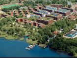
Masterplan, based on the above urban regeneration strategy, was created in January 1994. A total area of 207 hectares were divided into a total of 9 urban areas, 12) each of which had a differentiated urban design identity.
After reunification, Wasserstadt was launched with the purpose of housing supply to meet the social changes and demographic changes in Berlin. and a total of 12,700 new housing units were provided. and more than 90% of the total housing units were built in Sozialwohnungen type(Social welfare housing of public lease). A total of 1,280,000 square meters of commercial facilities were planned to attract 4,800 jobs. In addition, it created social infrastructures such as 3 elementary schools (Grundschule), 6 kindergartens, 4 indoor gymnasiums and youth activity centers, and other social infrastructure facilities so that Wasserstadt could be used for various purposes including various urban functions. A total of 21.5 Hectare green spaces and open spaces were placed throughout the waterfront so that waterfront was a universal place with no restrictions to access and utilization of citizens.
Berlin city government set up three major urban design principles and implemented urban regeneration. First, within the framework of the long-term development of Berlin city planning, the continuity of existing Berlin urban design was applied to the suburban Wasserstadt urban regeneration zone.
Second, the overall urban space ensures the unity of the waterfront design. Finally, with the order of urban design, the land use plan should be established to secure the identity of waterfront suitable for the urban context, and a detailed area plan should be developed for each urban area.
It was not a one-time, short-term, one-time city policy project, but a long-term development stage to become a urban regeneration project that realized in a long-term flexible way. The large scale Wasserstadt areas with a total area of 207 hectareswas divided into 9 zones, and the direction of development was decided and developed sequentially from the south to the north, and from the west to the east. In this way, it could flexibly respond to social and economic changes that might occur during the development process, and in the long term, urban regeneration of waterfront made to maintain total continuity.
4.3. Analysis of detailed planning contents of Wasserstadt Berlin
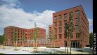
The Pulvermuehle area and Havelspitze area of Wasserstadt, which ws divided into 9 urban areas, are representative residential area and were completed and moved-in at the end of 2000.
A common characteristic of residential complexes in two urban areas was that residential complexes were planned in a 5- to 7-story block type, which designed the residential complex to be planned. The layout of Block by area, structure of Unit, Open Space and Urban Public Space associated with waterfront under the common context and order of the urban design, each of them was individually designed so that the quality and location of the urban space were given.
In case of Pulvermuehle area with a total areas of 37 hectares, public housing and residential construction company (Gemeinnuetzige Siedlungs-und Wohnungsbaugesellschaft mbH abbreviation GSW) became the subject of development and constructed the residential complex by supplying social welfare housing (Sozialwohnungen) for public lease. The Nalbach + Nalbach city architecture office, which was elected to the International Competition in the residential complex in Pulvermuehle area, was a five-story to seven-story building with cube-shaped buildings measuring 16m x 16m and typical building of existing Berlin houses ㄱ, ㄷ column type building deviating from ㅁ block type was placed facing horizontally.

Residential urban area in Pulvermuehle (source : www.berlin.de)
According to the layout and form of the ㄱ and ㄷ type column houses, the outer and inner boundaries of the complex did not exist and all were connected with open relationship. In this way, the entire Pulvermuehle area was made to have interchange of internal and external spaces as single zone.
The Havelspitze area was planned by the Dutch architect Kees Christiaanse, and the residential complexes were arranged in typical seven-story block ㅁ type block connecting the traditional block type tradition of the existing Berlin housing complex. Through this, each Block had a complete structure that divided the inner and outer spaces of the complex Centered on a typical, wide courtyard. The wide courtyard serves as a spatial center for the formation of a community of residential complexes that provided a place for casual encounters of residents and a place for diverse public activities and private leisure activities. Each unit had a terrace and was arranged around a wide courtyard so that the sun, light and visual green space could be secured to realize the health and comfort of the residential environment. And the outer space of the complex was facing the waterside, and the waterside promenade close to the outer boundary and with the closest access to the water were created.
Haveleck area was used as an old petroleum storage building and was restored to environmentally friendly through land purification treatment and pollution prevention work on the polluted environment. After that, 210 household 3 story medium and low story villa houses and terrace type detached house.
were constructed. Haveleck area did not follow the tradition of Berlin urban design pursued by Pulvermuehle area Havelspitze area of Wasserstadt, that is, 5 to 7 story block building.13)
It was designed in an attempt to create a city space in which various types of people live together in Wasserstadt so that various forms, sizes, floors, and layouts of residential facilities are formed by planing appropriate small sized detached housing and complex housing within the framework of the tradition of Berlin city design.

Residential urban area in Havelspitze (source : www.berlin.de)
The Schultheiss, Eiswerder and Parkstrasse urban areas in Wasserstadt, were regenerated as multi-purpose zone with functions of medical, office, education, culture and service spaces, including the 215 hiusehold scale of residential elderly care apartment units.
To compensate for the inconvenience of long commutes and distance between residence, work and school located in the suburban area, Wasserstadt planned residential, work and diverse cultural, educational and service facilities in a pleasant environment on the waterfront. In other words, Wasserstadt provided urban facilities so that busy modern people could live a balanced life of the day, by making the residential area, the work place, the residence area and the education facility as one urban space, enabling short commuting distance and school distance. This led to the implementation of a waterfront with a wide range of urban functions and reception and attraction that would enable various activities of the city's residents (housing + work + leisure) to take place.

urban regeneation project area “tSchultheiss” (source :Senatsverwaltung fuer Stadtentwicklung, 2007, p.16)
The Schultheiss, Eiswerder and Parkstrasse urban areas of Wasserstadt were used as industrial spaces since German Industrial Revolution and the existing buildings used for the modernization and urban development of the city of Berlin were recognized as historic places and designated as cultural property (Baudenkmalen) by Berlin city government.
The appearance of buildings designated as cultural properties were preserved and re-created as a space to contain new urban functions. In other words, the physical environment of internal space was renovated and the aged facilities were replaced to accommodate office space, service, and cultural space. In addition, as the importance of using eco-friendly energy and energy saving was emphasized, solar power generation system was installed on the roof of building and windows were replaced with double windows including Roy argon glass to increase the heat effect in winter and to prevent external heat input in summer for energy saving effect.
The new buildings were designed to establish Detailed Design Plan for the facade materials and colors, and to plan according to design guidelines to maintain uniformity with the existing exterior form of the historic buildings. In this way, the new architecture harmonizes with the existing urban context to form a continuous sense of space and form, and to maintain and preserve the existing urban context and historical traces.

Recovery of the historical Buildings “Schultheiss-Brauerei”
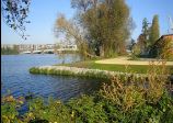
The waterfront, which was a hydrophilic natural space, made the most of location advantages and created a 21.5 hectare green space and open space and created 6,5 km long walkway connecting the parks and open spaces in each area along waterside with regeneration method without the artificial modification or damage of the natural terrain (hand-made line and water line) and Wasserstadt formed a green network and also made the physical harmony between natural space and urban space.
Under the slogan of returning the waterside space waterfront, which ws abandoned due to the disconnection, indifference, and neglect of the urban space due to industrial use of waterfront over the past years, it planned a culture, sports and leisure space including a fishing spot, a water-playing field (swimming pool), a yacht, a boat marina, and a playground, to transform a urban space where casual meeting and contact were held with the daily life of residents staying, and a pleasant and energetic place where play and leisure activities were done naturally.
Biotope were created as habitat for wild animals and plants in waterfront to enable people to live and coexist with natural communities of animals and plants. This attempted to improve the quality of the urban environment by focusing the natural value of the waterfront as natural ecosystem, which was a natural state, away from the place where the waterfront provided just leisure and rest for human life.
It reminded that urban space inhabited by urban residents was not just a space for humans but a part of nature, and implemented Wasserstadt outer space plan so that the functions, aesthetics and environment of city were composed in harmony with nature, and strived to protect and restore the ecological environment so that the waterside space as a place where diverse biological communities inhabited and place where local residents could interact directly with plants and plants and experience were created around waterfront.

Eco-Friendly Environmental Design
The problem of urban design called “disconnection of urban space” was pointed out because Wasserstadt was divided into three major sections as Wasserstadt was divided into two parts of the eastern area (Haveleck, Salzhof, Pulvermuehle) and the western area (Parkstrasse, Nordhafen, Maselake Zentrum, Maselake Nord, Havelspitze) by the Havel River, and Eiswerder area was an island.
To complement this, 8 bridges were newly planned considering the connection with the city center and the access from the outside of site, and Spandauer See Bruecke with a total length of 300m and Wasserstadtbruecke with a total length of 200m were completed and opened. The 13,7 km road was newly created to make the physical union of the urban space, and planned the local people to recognize and live the whole area of Wasserstadt as a whole urban area without break of the urban space. To enhance the pedestrian accessibility of Wasserstadt, 8 bridges for pedestrian and bicycle were newly installed and the whole area was planned to be accessible by foot and bicycle.
The newly installed bridges and roads not only functioned as urban spaces that make Wasserstadt, which was divided into nine zones, into an integrated urban zone, but also made Wasserstadt closely connected with the surrounding area and extend the effect of urban regeneration to the surrounding area, thereby expanding the city as a whole.
5. Conclusion and Implications
5.1. Conclusion
Through case analysis of Wasserstadt Oberhavel-Berlin, which was the center business of urban change in the suburban area of Berlin after German reunification and the representative success case of the urban regeneration of the waterfront, the strategy and characteristics applied to the urban regeneration of the waterfront located in the suburban area were derived. First of all, the results of this study are summarized as follows.
First, it establishes the urban function and identity of waterfront which conformed to order of urban design and urban context. In other words, it can be interpreted as “the connection of the waterfront and the relative context of urban space”.
Wasserstadt waterfront urban regeneration made waterfront and urban space designed to form a mutual relationship with each other's purpose and function, by placing the city functions and various city spaces (residential + work + leisure) required by the diverse activities of urban residents immediately adjacent to the waterfront or in close proximity to waterfront by the medium of park (green space).
“The connection of relational context between waterfront and urban space” is prominent in residential areas. Pulvermuehle and Havelspitze areas, typical residential area of Wasserstadt, form a different relationship with the waterfront in the layout of block and composition of units.
The residential complex in Pulvermuehle area was not arranged the block directly facing the waterside, and created two parks (Krienicke Park and Gruetzmacher Park) with a total area of 7,6 ha between the two spaces to emphasize the openness of waterfront. This allowed access to the waterfront from any location within the complex and allowed residents to be drawn into the waterfront. On the other hand, the residential complex plan in Havelspitze area arranged 2 to 3 meters walkway between the block and the waterside, with the block facing the waterside. This was to arrange the complex to conform to the shape of the earth and to plan the movement in the open form towards the waterside. In addition, a terrace type residential unit that can overlook the waterside was planned to form a close connection between the land, the complex and waterside.
The important implication for connection of relational context of waterfront and urban space is to ensure the diversity of the waterfront and the value of the quality and location of the urban space by designing a design that takes into account the topography and characteristics of the waterfront of each zone in layout of blocks and the composition of units.
Second, it is the extension of identity of urban space to suburban area through traditional succession and continuity of urban design. This can be interpreted as “connection of relational context between existing urban area (urban center) and suburban area”.
Berlin city as a whole had a long-term urban development plan, including Wasserstadt, which was planned to be developed and divided into 9 urban areas in Wasserstadt, and each area established a area detailed plan to have differentiated urban design characteristics in the nature of urban functions that fit the context of urban space. The shape of buildings in each area should be designed as a 5 - to 7-story horizontal block type according to Berlin urban design tradition and to mix urban functions such as residential, commercial and service facilities. The mediator of relational context of the existing urban space (urban center) and suburban waterfront is maintenance and succession of the urban design tradition. In other words, by applying the tradition of urban design in Berlin, the urban regeneration of the suburban area is made to conform to the context of existing city and achieve the continuous development. It was also recognized as historic place of modernization and urban development in the city of Berlin, and by preserving the exterior form of the buildings designated as Baudenkmalen (architecture cultural property) by the Berlin city government and transforming them into space that can accommodate new urban functions, the history and the present of the urban space are made to contain at the same time.
If the first conclusion mentioned above “the connection of relational context of waterfront and urban space” and the second conclusion “the connection of relational context of existing urban space (urban center) and suburban area” are conclusion of “study conforming to context of urban design and maintenance of tradition, building of history and place“details of residential space regeneration and complex function regeneration of urban point of view, the analysis framework of this study, the third and fourth conclusions from the social point of view, and the final conclusion can be said to be a comprehensive conclusion that analyzed Wasserstadt from the environmental point of view.
Third, Wasserstadt allowed more than 90% of the 12,700 households to be constructed in the form of Social welfare housing of public lease (Sozialwohnungen) and created waterfront walkways, open spaces and parks that connect waterfronts. This was to prevent privatization of the waterfront and ensure the public freedom of use and access to water.
In the residential complex plan, by various forms, sizes, floors, and layout of residential facilities through “connection of relational context of waterfront and urban space” as described above, the waterfront was planned strategically to serve as universal location for the centralized social space of the region by avoiding the rigidity of the quantitative distribution method of standardized space and adopting the qualitative sharing of urban space in a more natural way.
Fourth, waterfront regeneration for mixed use was carried out to promote the daily life of residents such as housing, service, work and leisure. Each functional space was planned to be integrated into an object of common urban element called waterfront, which gathered various urban activities and extensive urban functions to any place any area and any space of Wasserstadt.
The strategy pursued by waterfront urban regeneration from the social point of view showed that the urban regeneration of Wasserstadt provided a sustainable social renewal base by securing to enhance accessibility and openness of waterfront and the universality of waterfront as a social space.
Finally, from the environmental point of view, by creating a green space of 21.5 hectares and an open space, along the waterfront along a 6,5 km long walkway connecting the parks and open spaces of each area, the waterfront was restored to a place of leisure and rest of the citizens, and created Biotope of the plants and plants to restore and preserve the natural environment.
5.2. Implications
Waterfront urban regeneration in suburban area, Wasserstadt, can be divided into three main implications through case analysis.
First, to establish a urban regeneration strategy that results in “establishing the relationship between waterfront and urban space” and “establishing the relationship between existing urban space and suburban waterfront”, long-term urban development master plan (land use plan) is a prerequisite, and according to the master plan, an appropriate strategy is needed to adapt the spatial function of the urban context and the waterfront to establish the identity of the waterfront and accommodate the new urban functions.
Second, urban regeneration strategies should be developed to restore the inner functional qualities of the waterfront as a natural open space, rather than an artificial waterfront reconstruction. In other words, in the urban regeneration waterfront space utilization strategy, the direction of the urban design for the waterfront should get out of the purpose of merely providing the urban and spatial functions, and embrace the rich and abundant natural environment function originally contained in the waterfront. In addition, it should be recreated as a waterfront experiencing nature in the city, living together with nature, animals and humans. To this end, urban design strategies that derive a rational approach based on an understanding of ecological, friendly and sustainable urban regeneration should be established
Finally, it is the role and social responsibility of architects, urban designers and related specialist groups in urban regeneration. As the analysis of the process of urban regeneration of Wasserstadt, a study and proposal of urban regeneration of Leibniz-Gruppe consisting of four architects and design professors and practitioners (architects, urban designers) was the driving force of Wasserstadt project. For the development of urban regeneration in Korea, the proposal for urban renewal urban regeneration to analyze the urban problems and find the driving force of sustainable growth of the city should be constantly produced by the architects, urban designers and experts of related fields. When positive social debates on these proposals are actively developed and social maturity is promoted through urban policy through reasonable decision making, The urban regeneration policy of Korea will leap to a higher level.
Acknowledgments
This work was supported by the Soonchunhyang University Research Fund (No. 20160221)
This work was supported by the National Research Foundation of Korea(NRF) grant funded by the Korea government(MSIP; Ministry of Science, ICT & Future Planning) (No. 2017R1C1B5017517).
Notes
The ten principles for the development of sustainable waterfront was first introduced in Korea in the study paper Jeong Gyu-sik (2 others, 2011) “Comparative analysis on case city of urban regeneration through waterfront regeneration - Focusing on the United Nations Waterfront Ten Principles and Small and Medium Cities of the Korea Strait.”
References
- Anna Maria Odenthal, “Baudenkmale in der Wasserstadt Oberhavel”, Berlin, (2004).
- Hans Joerg Duvigneau, “100 Jahre Berliner Wohnungsbau von der Mietskaserne zur Reformwohnung”, (2006).
- Jong-Ki Park, “Fluss als Staedtebauliches und architektonisches Element der Stadterneuerung”, Berlin, (2010).
- Klaus Zillich, “Gewaesserschutz durch Wasserstadt”
- Klaus Zillich, “Liquid City Projekt- Das Wasser der Stadt”, internationales Symposium an der TU Berlin-Fakulität Architektur Umwelt Gesellschaft, Berlin, (2004).
- Maria Berning, Michael Braum, Jens Giesecke, Engelbert Lütke Daldrup, Klaus-Dieter Schulz, “Berliner Wohnquartiere. Ein Führer durch 70 Siedlungen”, 3.Auflage, Berlin, (2003).
- Leibnizgruppe, “Projekt Wasserstadt BerlinOberhavel”, Berlin, (1990).
- Senatsverwaltung fuer Stadtentwicklung, “Berliner Entwicklungsbereiche”, Berlin, (2007).
- Senatsverwaltung fuer Stadtentwicklung, “Staedtebaulicher Entwicklungsbereich Wasserstadt Berlin- Oberhavel”, Berlin, (2007).
- Senatsverwaltung für Stadtentwicklung und Umweltschutz, “Flächennutzungsplan Berlin. Erläuterungsbericht”, Berlin, (1993).
- Stadt Fuerstenwalde/Spree, “Intergriertes Stadtentwicklungkonzept Fuerstenwalde/Spree”, (2007).
- Wasserstadt Gmbh, Berlin, “Neue Adressen am Wasser”, Dokumentation des europäischen Kongresses, vom 23(bis 25), Oktober 1997 in Berlin Berlin, (1997).
- www.berlin.de
- www.difu.de, (Deutsches Institut fuer Urbanistik)
- www.wsv.de, (Wasser-und Schiffahrtsverwaltung des Bundes)
- Kim, Min-Kyung, Lee, Jung-hyung, “A Study on the Characteristics of Design for Renewal of New York Manhattan Waterfront for Downtown Revitalization ”, Journal of the Architectural Institute of Korea Planning & Design, Vol.25(No.4), (2009).
- Rinio Bruttomesso, “City and Water, Building & Culture, Vol.11, (2000).
- Lee, Kum-Jin, “The Mixed-use Waterfront Development for Urban Regeneration and Regional Revitalization: A Case Study of Brindleyplace Birmingham”, Journal of the Architectural Institute of Korea Planning & Design, Vol.24(No.3), (2008).
-
Park, Jong-Ki, A Study on the Characteristics of Urban Regeneration for the local City “Cottbus” in Germany, Journal of the Architectural Institute of Korea Planning & Design, Vol.30(No.11), (2014).
[https://doi.org/10.5659/jaik_pd.2014.30.11.147]

-
Park, Jong-Ki, A Study on the urban Characteristics of Design for Urban Regeneration based on Cultural Strategy -Focused on the case of Ruhrgebiet, Germany-, KIEAE Journal, Vol.13(No.4), (2013).
[https://doi.org/10.12813/kieae.2013.13.4.075]